-
CityHall
-
- City Council Council Goals Council Meeting Information Council Members Public Hearings Strategic Plan Boards & Commissions Fruita Housing Authority Housing Authority Meetings
- City Manager Organizational Chart Weekly Information Updates Welcome to Fruita City Staff Directory Stay Informed Community Engagement Fruita in the News Weekly Information Updates
- Departments Administration City Manager Engineering Human Resources Municipal Court Parks & Recreation Community Development Police Public Works Utility Billing
- Quick Links FAQs Agendas & Minutes Emergency Alert Sign Up Fruita Municipal Code Job Opportunities Maps and GIS Meeting Calendar Ordinances and Resolutions Community Resources
-
-
Business &Development
-
- City Resources Business Development in Fruita Land Use Code Transportation and Parking Planning Commission Monthly Development Reports
- External Resources Grand Junction Economic Partnership The Business Incubator Center F-Works Co-working space Mesa County Enterprise Zone Fruita Chamber of Commerce Mesa County Workforce Center
- Bids and RFPs Code of Ordinances Forms and Permits
-
-
Recreation& Events
-
WhyFruita?
-
- Why Fruita? About Community Overview Welcome to Fruita History Community Surveys Events and Activities City Calendar Stay Informed
- Fruita Tourism Colorado National Monument J.M. Robb CO River State Park Highline Lake State Park Colorado Canyons Association Dinosaur Journey Museum Rim Rock Adventures Colorado Welcome Center Over The Edge Sports Colorado Backcountry Biker
- Gemini Adventures Mike the Headless Chicken Weather Education School District 51 Colorado Mesa University CMU Tech
-
Fruita Wayfinding Routes
Internal Wayfinding Trails in the City of Fruita
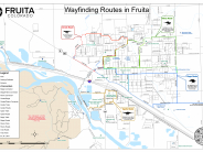
Funded by a grant from the Colorado Department of Transportation, the City of Fruita recently created four wayfinding routes throughout town to help guide pedestrian and bicycle traffic. Many maps have been installed, and pavement markings along the routes have also been installed to help guide users along each route. The routes were created with pedestrian and bicycle safety in mind. The routes use off-street trails and roads with wide shoulders or sidewalks, as much as possible.
More information on each route can be found here:
- Fruitadens/Green Route - The FruitaDens/Green Route is a loop that includes access to the Fruita Community Center, Little Salt Wash Park, the Little Salt Wash Trail, and the Fremont Street (18.5 Road) pedestrian trail.
- Apatosaurus/Orange Route - The Apatosaurus/Orange Route is a short route on the southside of Fruita (south of Interstate 70), and uses the Colorado Riverfront Trail and the trail in the state park to help users along the route.
- Ceratosaurus/Red Route - The Ceratosaurus/Red Route runs along the northwest side of Fruita.
-
Stegosaurus/Blue Route - The Stegosaurus/Blue Route includes access to Circle Park, Fruita Monument High School and the Fruita 8/9, downtown Fruita, and more.
You can download a .pdf version of the wayfinding map from the link below.
Click any thumbnail image to view a slideshow

